1877
Poonjar Concession: examine the agreement and its relationship to high-range transport.
A historic route. A lifeline for connectivity. A vision for sustainable development.
Our demand is clear: official survey, inter-departmental coordination, a transparent DPR, and a time-bound decision. NH 85 is not the opponent; Rajapatha is proposed as a complementary parallel route.
The Council seeks a coordinated government review of the historic corridor, its land records, engineering feasibility and environmental requirements.
The historic corridor connects the Aluva region with the high ranges through Perumbavoor, Kothamangalam, Thattekkad, Kuttampuzha and Pooyamkutty towards Perumbankuthu and Munnar. The Council seeks a transparent government review of its present status and restoration feasibility.
The representation describes the Old Aluva–Munnar Rajapatha as a historic route linking coastal trading centres with the High Ranges of the Western Ghats. Historical maps, survey plans and government records should be examined by the relevant authorities to confirm the route’s history and present legal status.
Study the historic links between coastal trade and transport into the High Ranges using documentary evidence.
Read moreReview historic survey plans, revenue records, PWD records and relevant government orders together.
Read moreDocument surviving traces of the historic route and consider heritage and environmental safeguards in any development decision.
Read morePoonjar Concession: examine the agreement and its relationship to high-range transport.
Travancore Gazette: verify the precise land area and geographical scope of the notification.
Floods and route changes: document the reported connection using historical sources.
The representation submitted on behalf of tribal residents and the general public calls for restoration of the historic route through Kothamangalam, Thattekad, Pooyamkutty, Kurathikkudy and Perumbankuthu towards Munnar. The request is not to oppose NH 85, but to develop a complementary parallel route after proper technical, legal and environmental assessment.
NH 85 is a vital existing highway to the High Ranges. Rajapatha is not proposed against NH 85 or as a campaign to undermine it.
Read moreStudy whether Rajapatha can add another connectivity option, improve network resilience and support people and villages along the corridor.
Read moreVerify route length, gradients, land status, forest permissions, construction costs, ecological effects and travel-time estimates in a DPR.
Read moreCompare the proposed Old Aluva–Munnar Rajapatha with the existing NH 85.
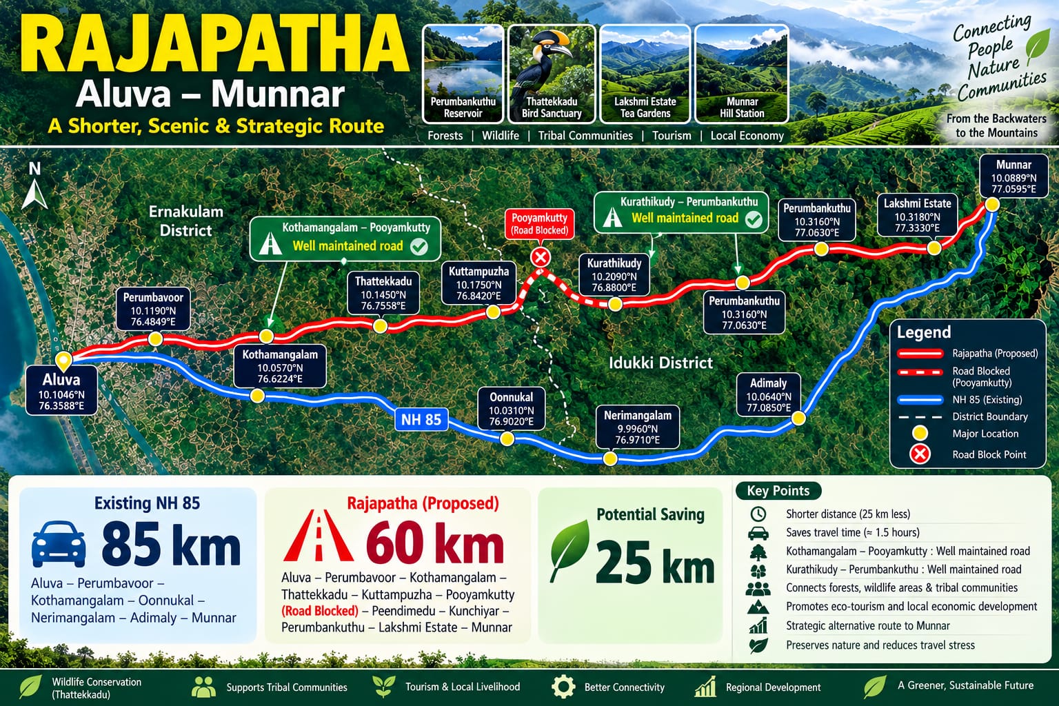
Schematic based on the supplied campaign image; not to scale. The 85/60 km figures have not been independently verified. A survey must establish distances between identical endpoints. This illustration does not establish current access or legal status.
NH 85
The route
Per complete one-way journey
An illustrative scenario for trips switching to a shorter route after reopening.
Formula: distance saved × one-way vehicle trips/day × days/year × kg CO₂/vehicle-km ÷ 1,000 = tonnes CO₂/year.
The default 1,000 trips/day is an assumption, not a traffic survey. The 0.249 kg/km factor converts the US EPA passenger-vehicle benchmark of about 400 g/mile (400 ÷ 1.609344 ÷ 1,000). It is not a measured Kerala fleet factor. Adjust it for local vehicles, fuel, gradients and speeds.
This estimates distance-related tailpipe CO₂ only. It excludes construction, land-use change, forest and biodiversity impacts, maintenance, fuel production and induced traffic. It is not the project’s net carbon benefit, and it does not claim savings are occurring today.
US EPA — emission factor reference ↗Historic corridor and present road access must be distinguished. No inspection date or verified current status has been supplied.
| Section | Current status | Last verified / source |
|---|---|---|
| Aluva–Kothamangalam | Verification pending | Not supplied |
| Kothamangalam–Kuttampuzha | Verification pending | Not supplied |
| Kuttampuzha–Pooyamkutty | Verification pending | Not supplied |
| Pooyamkutty–Perumbankuthu | Verification pending | Not supplied |
| Perumbankuthu–Munnar | Verification pending | Not supplied |
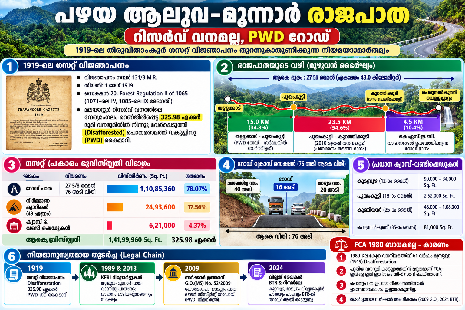
The supplied campaign notes describe a 43 km Kuttampuzha stretch split into sections and claim that some portions are already motorable. These figures should be checked by joint field inspection and official road records before they are presented as confirmed.
| Campaign-reported section | Reported length | Verification needed |
|---|---|---|
| Thattekad – Pooyamkutty | 15.0 km | Confirm road ownership, surface condition, public access and current vehicle use. |
| Pooyamkutty – Kurathikkudy / forest check-post stretch | 23.5 km | Confirm alignment, access restrictions, land status, bridges and ecological constraints. |
| KSEB-used road section | 4.5 km in the supplied route breakdown | Verify the route, permitted uses and current engineering condition with KSEB and relevant departments. |
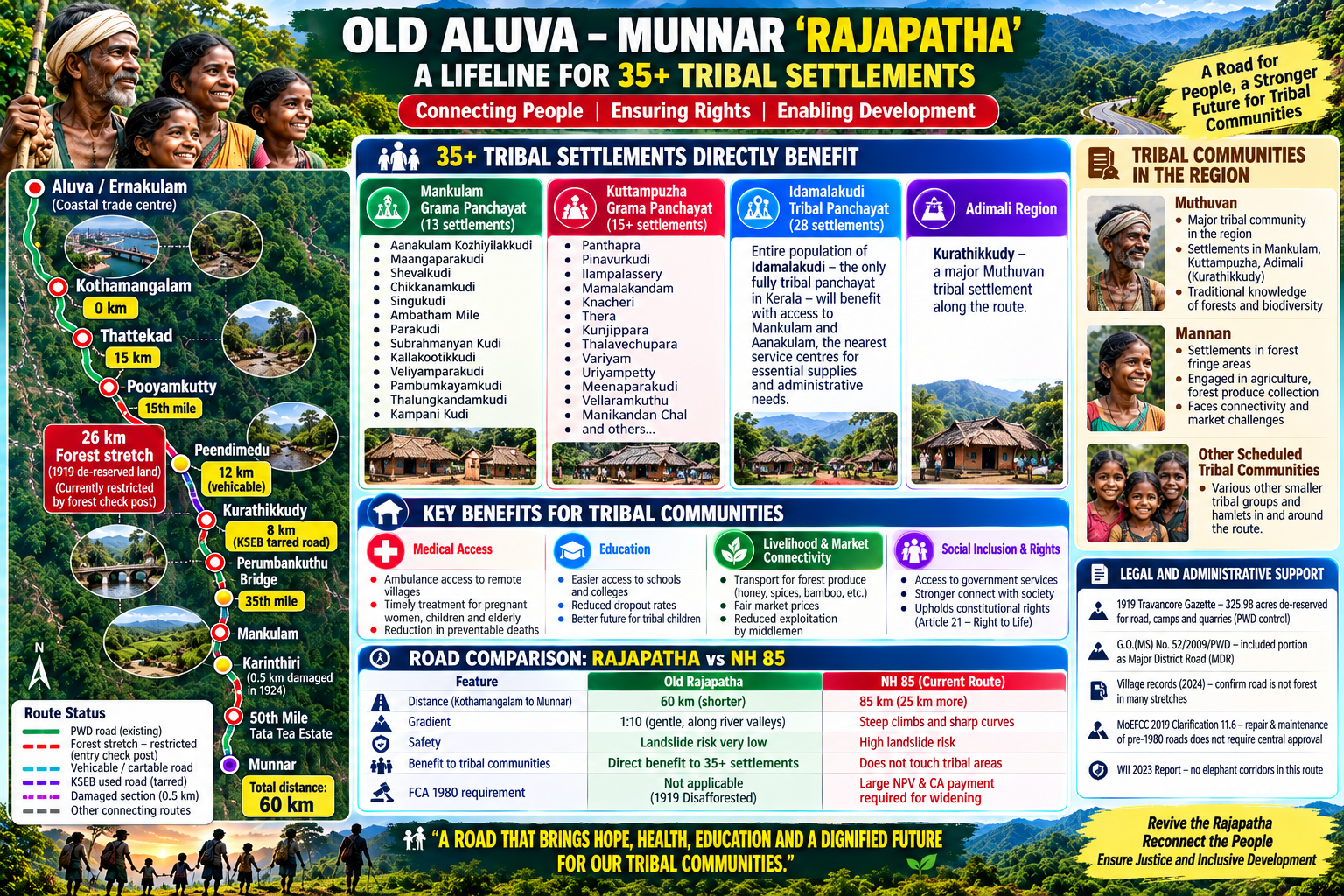
The supplied infographic also refers to an 8 km BM&BC section and other existing road portions. Lengths and endpoints differ between the provided materials; a single surveyed route schedule is needed to reconcile them.
The proposed Old Aluva–Munnar Rajapatha is presented as a shorter, scenic and strategic parallel corridor to NH 85. The campaign infographic highlights the route via Aluva, Perumbavoor, Kothamangalam, Thattekad, Kuttampuzha, Pooyamkutty, Kurathikkudy, Perumbankuthu, Lakshmi Estate and Munnar, alongside potential benefits for connectivity, tourism, tribal communities and local livelihoods.
The infographic's distance and travel-time figures (85 km via NH 85, 60 km proposed Rajapatha and 25 km potential saving) are campaign estimates, not independently verified measurements. Final alignment, road condition, blocked sections, permissions, environmental impacts and feasibility should be established through official survey and the DPR.
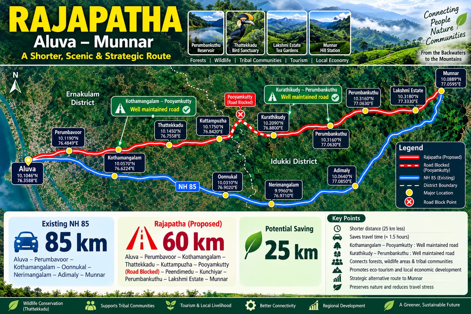
The submitted representation reports an estimated 60 km Royal Way corridor compared with an estimated 85 km via NH 85. These are campaign figures that require official survey. The central demand is that government agencies verify the route on the ground and publish a DPR rather than leave the proposal unresolved.
| Factor | NH 85 — existing highway | Rajapatha — proposed parallel option |
|---|---|---|
| Distance | Campaign estimate: 85 km from Kothamangalam to Munnar. | Campaign estimate: 60 km; claimed saving of around 25 km. |
| Travel time | Can be affected by curves, traffic and monsoon disruption. | Potential improvement must be established through route and travel-time studies. |
| Geology & safety | Some stretches are vulnerable to landslides, rockfalls and heavy-rain disruption. | River-valley alignment is not automatically safer; slope, flood, wildlife and geotechnical risks must be assessed. |
| Land & forest approvals | Widening requirements and related costs depend on the approved design. | Historic road records and the claimed 1919 de-reservation / 76-foot PWD width must be verified from official records. |
| Cost & readiness | Maintenance and improvement costs require current official estimates. | Existing road sections may help, but missing links, bridges, drainage and safeguards need costing. |
*Distance figures are reproduced from the campaign proposal and should not be published as verified route measurements until surveyed.
The representation identifies tribal settlements in Kuttampuzha, Mankulam, Adimali and Edamalakudy and argues that improved connectivity could support access to healthcare, education, essential services and markets. Government departments must consult the affected communities directly, verify settlement details and include their priorities in the DPR.
Assess whether all-weather road access could improve ambulance response and transport for patients, pregnant women and older residents.
Read moreConsult families about travel to schools, colleges, health centres, government offices and essential services.
Read moreExplore fairer access to markets for agricultural produce, honey, spices and traditional products, with safeguards against exploitation.
Read moreAreas for consultation: Kuttampuzha, Mankulam, Idamalakkudy and the Adimali region, including Kurathikkudy. The supplied campaign notes refer to Muthuvan and Mannan communities and to 35+ settlements. Names, spellings, population figures, route proximity and expected benefits must be validated with the respective local bodies and community representatives before publication as official facts.
Read moreFor remote settlements, road connectivity can shape access to healthcare, education, emergency response, markets and public services. The Government should assess Rajapatha not only as a transport corridor, but also for its potential to support village development, responsible tourism and local livelihoods—with tribal communities involved in decisions that affect them.
Study whether an alternative corridor could improve ambulance access, disaster response and route resilience during closures on the existing highway.
Read moreWork with communities in and around Kuttampuzha, Mankulam and Idamalakkudy to understand needs for healthcare, education, transport and market access.
Read moreExplore community-led eco-tourism, village experiences, local guides, homestays, traditional food and cultural heritage—with community consent and environmental safeguards.
Read moreAssess practical improvements to year-round access to schools, hospitals, public services and emergency facilities.
Read moreBetter connections may help village shops, farmers, artisans, local guides, homestays and small enterprises reach visitors and markets more fairly.
Read moreRequire biodiversity, hydrology, cumulative-impact and social-impact studies before selecting any alignment or construction method.
Read moreThese animations explain the concepts; they are not footage of the actual locations.
Development must be evidence-based. Assess each stretch before deciding alignment, construction or permissions.
Verify forest/revenue boundaries, wildlife movement and habitat continuity.
Study slopes, drainage, bridges, existing road assets and minimum-construction alternatives.
Determine applicable permissions from current records and proposed works; plan mitigation and monitoring.
Subject to government study and required approvals, assess responsible tourism opportunities along Rajapatha that could support local guides, homestays, farmers, artisans and traditional food enterprises.
Explore opportunities for local products and small enterprises to reach markets.
Read morePrioritise nature protection, local culture and the consent of communities.
Read moreInclude the views of tribal communities and village panchayats in planning.
Read moreThe campaign has identified historical land records, government orders and survey records that may be relevant. Their exact wording, applicability and current legal effect should be reviewed by qualified professionals and competent authorities.
Campaign material refers to a Travancore Gazette notification and an extent of 325.98 acres said to have been de-reserved and transferred to the Public Works Department. Publish a certified copy and authenticated survey schedule to substantiate the claim.
Read moreReview the cited KFRI reports from 1989 and 2013, current forest maps, road registers, village records, BTR entries and resurvey documents. Record any disputed sections and access restrictions accurately.
Read moreThe supplied material cites G.O. (MS) No. 52/2009, 2019 MoEFCC guidance and court decisions on road access. Confirm the exact documents, case citations, scope and applicability before making legal conclusions.
Read moreWhether forest-clearance requirements apply depends on the land's legal status, the work proposed, the relevant dates and applicable law. Wildlife corridors, elephant movement, biodiversity, flood risk and community rights require evidence-based assessment. This demo does not assert that any approval is unnecessary or that a court has approved the proposed route.
Read moreTwo supplied publications explain the campaign and the records it cites.
Search the document descriptions, expand their source summaries and download the full compendium.
Read moreRead the complete supplied article on history, community access, existing assets, the legal case and a proposed DPR.
Read moreRequests for government action; these do not mean restoration has been approved.
Coordinate PWD, Forest, Revenue, Tourism and other relevant authorities.
Establish alignment, land classification, boundaries and existing assets.
Clarify the 1919 notification, current land records and required permissions.
Investigate bridges, slopes, alternatives, costs and a Detailed Project Report.
Record community priorities and provide meaningful local participation.
Study wildlife, ecology, mitigation and statutory clearances.
Publish a reasoned decision, action plan and progress updates.
The Rajapatha Development Council calls upon the Government of Kerala and the concerned authorities to take a clear, public and time-bound decision on restoring the Old Aluva–Munnar Royal Way as a parallel route to NH 85. The demands below state the campaign's position; questions of ownership, jurisdiction and statutory permissions should be addressed through official records and lawful process.
The Council asks that records and lawful jurisdiction be examined and Forest Department intervention on this road be ended where unsupported. Government should officially clarify ownership and control.
Read moreBring together the Public Works, Forest, Revenue, Transport and Tourism departments under the Chief Minister, announce the Government’s position and set a time-bound programme of action.
Read moreIn proceedings concerning restoration, the Council asks Government to support reopening on the basis of the available records, applicable law and public interest.
Read moreUnder PWD leadership, complete surveys, boundary verification, engineering review, required permissions and safety and environmental measures, then take steps to restore the route for public use.
Read moreOur position: This campaign is not against NH 85. It seeks parallel connectivity and better access to services, livelihoods and responsible tourism for tribal settlements and villages.
The Council asks that the Old Aluva–Munnar Rajapatha be assessed as a complementary parallel route to improve connectivity—not as a route opposed to NH 85.
Jointly examine land records and jurisdiction, and clarify the position of the departments concerned.
Read moreConvene a meeting of relevant departments and announce a clear position and time-bound action.
Read moreTake a position that protects the public interest based on available records and applicable law.
Read moreComplete required surveys, technical assessments, lawful permissions and safety measures, then restore the route.
Read moreWorking towards a practical solution through public consultation, documentary review, field visits and official representations.
Meet the people working to raise awareness about the historic Aluva–Munnar Rajapatha proposal. Replace each placeholder with a verified photograph, name and designation.
Name / Designation to be added
Name / Designation to be added
Name / Designation to be added
Name / Designation to be added
Name / Designation to be added
Name / Designation to be added
Name / Designation to be added
Name / Designation to be added
Name / Designation to be added
Name / Designation to be added
Name / Designation to be added
Name / Designation to be added
These are placeholders, not actual portraits. Add only photographs and names approved by the individuals concerned.
Meet the people joining hands for better public access.
Activist profiles will appear here.
Discover the Council’s latest activities, photographs and updates.
New activities will appear here.
A dedicated space for road views, village life, local tourism, cultural heritage, community meetings, field visits and development activities. Add verified photographs with captions, dates and locations after receiving permission where needed.
Gallery placeholders are intentionally left open for your photographs. Use images with permission and avoid publishing identifiable people, especially children, without appropriate consent.
Reference graphics supplied for this website demo. Their claims and figures should be independently checked before official or public distribution.
Follow the latest announcements, community activities and progress from the Council.
View all newsNews will appear here when published.
This preliminary timeline reflects records and activities referenced in the submitted representation. The current validity of each record and any subsequent action should be confirmed with the relevant authorities.
The representation refers to an agreement involving the Poonjar royal family and John Daniel Munro.
Read moreThe representation cites a government order including a portion of the old road as a Major District Road. The exact scope should be verified from the official order.
Read moreThe representation lists panchayat decisions, Village Officer reports, survey/revenue records and related correspondence.
Read moreThe Council seeks a joint departmental review, a clear government position, appropriate legal steps, preparation of a DPR and a feasibility study for safe and environmentally responsible restoration.
Read moreWatch public Facebook, Instagram and YouTube videos here.
Videos will be added here.
Understand the proposal and what still needs verification.
The status of each stretch must be verified separately. A historic alignment is not proof of current public access.
Its precise scope must be checked with the original notification and current official records.
Approval is not established by the supplied material. A survey, representation or preliminary study is not final sanction.
Read the documents, share relevant evidence and participate in lawful community consultations.
Share your view on the proposed Rajapatha feasibility study. Feedback shown here is only a local demo and is not published or transmitted to the Council.
Public comments can help identify access needs, safety concerns, environmental risks and questions for the feasibility study.
No ratings or testimonials are fabricated on this website. Public reviews should be published only after a real submission and moderation process is configured.
Add verified official phone, email and postal details here. The current form only prepares a text file on your device; it does not send a message to the Council.
Rajapatha Development Council
Verified contact details should be added before publication.
Share your viewsContact the Council to share public feedback, documents and suggestions.
Rajapatha Development Council Kuttampuzha, Kerala
Once the Council’s Blogger URL is added, recent news and announcements can be linked or displayed here.
Open Blogger